The photos and explanations for this assignment are based on observations made on February 8, 2022 at a geology lab at Utah State University on a small scale flume filled with different sized engineered sediment.
1. Flume Controls
1.1 Q (Water Discharge)
The water discharge is controlled by the pump system associated with the flume. There is a motor sitting in the outflow tank that recirculates the water back to the top of the flume to allow for continuous flow. The pump could provide a range of flows up to about 100 mL/s by rotating a dial on the control panel.
1.2 S (Slope)
The slope of the system could be changed via three factors: overall table/flume slope, local slope using the provided engineered sediment, and local slope by changing the outlet height or base level of the system.
1.3 Qs (Sediment discharge)
Sediment discharge is based on the amount of sediment suspended in the water column when the water leaves the system via the outlet plug. This means the sediment discharge was controlled by the height of the discharge plug, which dictated the local slope around the plug and relates to the amount of sediment leaving the system.
1.4 Profile
The profile changes as the slope or flow rate are changed. A higher slope directly changes the profile by increasing the head difference of the system, while changing the flow rate can change the power of the system, which could change the path of the water and therefore, change the profile. The profile can also change depending on man-made impacts to the system such as cutting new channels or armoring certain banks.
1.5 Base Level
The base level is changed by adjusting the height of the outlet plug of the system.
2. Fluvial Geomorphic Processes
2.1 Bed Erosion
Bed erosion occurs when sediment on the bed of a stream is picked up and moved downstream along the river bed. This process can be seen in the following video. There are lots of suspended grains in the flow but the white grains of sediment can be seen getting dislodged and rolling along the bed.
2.2 Bank Erosion
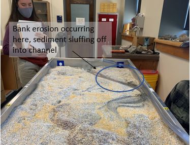
Bank erosion occurs when sediment along the bank is loosened by the force of the stream and falls into the flow. This process can be seen in the following video. This photo shows a bank at the upper end of the flume, on the outside bend of a large curve. Sediment from the upper edge of the bank is falling into the flow as the flow erodes away the lower section of the bank.
Bank erosion occurs when sediment along the bank is loosened by the force of the stream and falls into the flow. This process can be seen in the following video. This photo shows a bank at the upper end of the flume, on the outside bend of a large curve. Sediment from the upper edge of the bank is falling into the flow as the flow erodes away the lower section of the bank.
2.3 Deposition
Deposition occurs when sediment that was suspended in the flow or was moving with the flow settles out along the bed of the stream. The following video shows deposition of sediment grains at a fan type structure within the flume. The grains are depositing along the downstream edge of the fan.
Deposition occurs when sediment that was suspended in the flow or was moving with the flow settles out along the bed of the stream. The following video shows deposition of sediment grains at a fan type structure within the flume. The grains are depositing along the downstream edge of the fan.
2.4 Sediment Transport
Sediment transport occurs when sediment grains are moved from their original position by the flow of the stream. The following video shows sediment transport as both suspended load and bed load, depending on the size of the grain and the velocity of the flow.
Sediment transport occurs when sediment grains are moved from their original position by the flow of the stream. The following video shows sediment transport as both suspended load and bed load, depending on the size of the grain and the velocity of the flow.
3. Fluvial Geomorphic Mechanisms
3.1 Grain Size Sorting
Grain size sorting occurs when specific size sediments settle out of the flow uniformly according to sediment size. This can be seen in the following video with the red sediment (smallest grain size) falling out of the flow at the first inside bend, and the yellow falling out at the bottom.
3.2 Meandering
Meandering is when a stream becomes very sinuous or has lots of curvature to its shape. Meandering is hard to recreate in a lab setting but this video captures an artificially dug meandering channel.
Meandering is when a stream becomes very sinuous or has lots of curvature to its shape. Meandering is hard to recreate in a lab setting but this video captures an artificially dug meandering channel.
3.3 Braiding
Braiding in a river is when there are many diffluences and confluences along a river channel. in other words, there are multiple channels of similar size that are constantly dividing and coming back together. This video highlights some of the braiding that was seen in the lower portion of the flume.
Braiding in a river is when there are many diffluences and confluences along a river channel. in other words, there are multiple channels of similar size that are constantly dividing and coming back together. This video highlights some of the braiding that was seen in the lower portion of the flume.
3.4 Avulsion
Avulsion is when the flow breaks out of its current channel into a new channel. This video shows the flow avulsing from the main channel to form a new channel for most of the flow.
Avulsion is when the flow breaks out of its current channel into a new channel. This video shows the flow avulsing from the main channel to form a new channel for most of the flow.
3.5 Chute Dissection
Chute dissection is when the channel finds a new path that is more direct and less meandering. This could mean cutting off long meanders, cutting through a floodplain, or cutting across the inside bend of a curve, creating a bar in the center of the channel. The following video shows a chute dissection cutting off a meander in the channel.
Chute dissection is when the channel finds a new path that is more direct and less meandering. This could mean cutting off long meanders, cutting through a floodplain, or cutting across the inside bend of a curve, creating a bar in the center of the channel. The following video shows a chute dissection cutting off a meander in the channel.
3.6 Structural Forcing
Structural forcing is when a hard structure (boulder, tree, manmade object) obstructs the river flow and forces the flow to change paths. In the video below, the plant material moves the channel away from the wall and towards the center of the flume, altering the flow path.
Structural forcing is when a hard structure (boulder, tree, manmade object) obstructs the river flow and forces the flow to change paths. In the video below, the plant material moves the channel away from the wall and towards the center of the flume, altering the flow path.
4. Events
4.1 Small Flood
The base flow in this system was assumed to be between 20 and 30 mL/sec. The small flood in this video was approximately 50mL/sec for a long time period (>2 min). No significant changes were seen in the landscape after this flood.
4.1 Small Flood
The base flow in this system was assumed to be between 20 and 30 mL/sec. The small flood in this video was approximately 50mL/sec for a long time period (>2 min). No significant changes were seen in the landscape after this flood.
4.2 Large Flood
The base flow in this system was assumed to be between 20 and 30 mL/sec. The large flood in this video attempted to follow a typical flood hydrograph with a steep rising limb and a long falling limb. The peak was approximately 95mL/sec. This flood also did not significantly change the landscape but more sediment was transported in this event, meaning more change occurred during this flood than the small flood.
The base flow in this system was assumed to be between 20 and 30 mL/sec. The large flood in this video attempted to follow a typical flood hydrograph with a steep rising limb and a long falling limb. The peak was approximately 95mL/sec. This flood also did not significantly change the landscape but more sediment was transported in this event, meaning more change occurred during this flood than the small flood.
4.3 Channel Realignment (Grading)
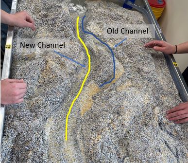
This channel realignment photo shows a meandering channel that is straightened through a dug channel that removes most of the meander. After the flow is routed through the straight channel, the flow increases velocity and moves lots of sediment towards the outlet.
This channel realignment photo shows a meandering channel that is straightened through a dug channel that removes most of the meander. After the flow is routed through the straight channel, the flow increases velocity and moves lots of sediment towards the outlet.
5. Analysis
5.1 From what you did, what seems to be the roll/impact of small floods vs. big floods?
In the short period of time that we ran the pump at flood levels, not much work was done with either flood. There was some sediment moved in both cases but there was not large scale destruction. For one version of the large flood, we left the flow on at a high level for a long time and this ended up wearing away a bank and the stream avulsed into a new channel. It could been seen that multiple large flood events could cause cumulative damage if allowed to erode the landscape before banks and vegetation could be reestablished, while small flood events might just readjust sediment locations within a channel.
5.2 In your experimentation, did you observe overbank flows, bankfull flows, and/or baseflow flows?
This depended on the flowrate and how long the pump had been running (or how long water had been flowing through the system). When a new channel was being cut at the beginning of an event, the flows were mostly bankfull or overbank flows, as the water traveled over the landscape instead of in the stream channel. Once the flow path was more establish, and especially when the pump was turned to a low level, there were lots of baseflow flows observed. This was most often seen towards the top of the flume where a more defined channel was found. Lower in the flume, closer to the outlet, the flow tended to leave a defined channel and spread out as the slope decreased.
5.3 What role did hyporehic flow play in what you observed?
There was a lot of subsurface flow observed in the flume. There were multiple instances of through flow (this is how the avulsion occurred in the video above). Because the sediment was engineered and many of the smaller particles had already been removed from the system, it was easy for the water flow below the ground surface due to the large pore spaces.
5.4 What roll did recession limb flows seem to play in what you observed?
We only made on scenario with a recession limb that was long enough to observe. In the large flood we had a rising limb that last about 15 seconds and a receding limb that lasted about 3 minutes. This receding limb did not seem to have much different effect than the rest of the flood. There was more deposition that occurred in the lower end of the flume during this time because the flowrates through the system were lower, allowing suspended sediments to fall to the bed. In terms of geomorphic work, there were not significant changes that occurred during the recession limb of the flood.
