I have chosen to do my final project on the Gallatin River in southwest Montana. I will focus on the stretch from the headwaters in Yellowstone National Park to Bozeman, MT. This portion of the river starts in a high elevation mountain range , winds through a narrow valley then exits onto a wide open plain before reaching the town of Bozeman. I spent significant time along this portion of the Gallatin from 2019 to 2021, while I lived in Bozeman.
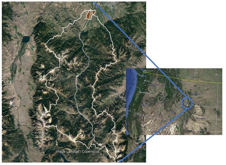
Figure 1: The Gallatin watershed is in southwest Montana. The headwaters are within Yellowstone National Park and the river terminates at its confluence with the Missouri River at Three Forks, MT.
The Gallatin River watershed is very mountainous and heavily vegetated in the headwater reaches and through the canyon. Once the river enters the Gallatin Valley, the slop significantly decreases and the land cover changes to more scrub and agricultural land (see Figure 2). The Gallatin River drains into the Missouri River at Three Forks, MT. There are many other watersheds in southwest Montana of similar size and discharge that eventually drain into the Missouri River. The climate in this region consists of cold, wet winters and hot, dry summers. The hydrograph is snowmelt dominated, with the peak discharge occurring in spring (usually sometime in May). The watershed is elongate in shape with a total river length of about 120km. This area was greatly influenced by glacial activity.
Five sites were selected along the river that are representative of the different reach types seen in this watershed. The first site is right below the headwaters in Yellowstone National Park. The second site is in an alpine valley where the reach has seen significant meandering. The third site is at the turn off for Big Sky, MT and shows a more anthropologically influenced landscape. The fourth site is in Gallatin Canyon, where rapids dominate the riverscape. The final site is in Gallatin Valley, where the river has more room to spread out and create gravel bars and islands. Figure 4 shows the locations of the sites along the river profile.
Five sites were selected along the river that are representative of the different reach types seen in this watershed. The first site is right below the headwaters in Yellowstone National Park. The second site is in an alpine valley where the reach has seen significant meandering. The third site is at the turn off for Big Sky, MT and shows a more anthropologically influenced landscape. The fourth site is in Gallatin Canyon, where rapids dominate the riverscape. The final site is in Gallatin Valley, where the river has more room to spread out and create gravel bars and islands. Figure 4 shows the locations of the sites along the river profile.
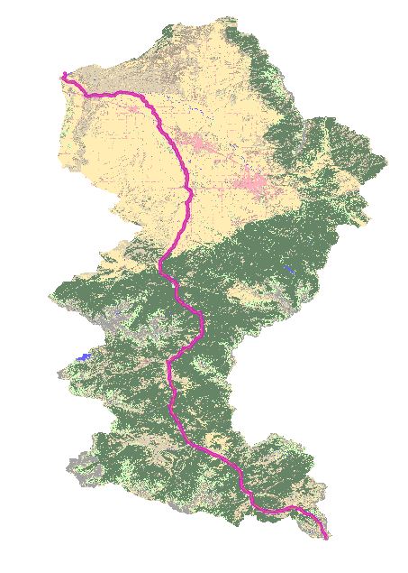
Figure 2: The Vegetation classes in the Gallatin River Watershed. The tan symbolizes scrub and the green symbolizes forest, with the pink being urbanized areas.
|
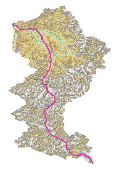
Figure 3: The detrended DEM of the Gallatin River Watershed. This watershed starts in a very mountainous area and eventually drains into a wide valley. this is common topography for areas carved by glaciers.
|
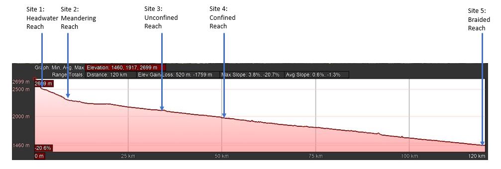
Figure 4: The river profile for the Gallatin River. This river concave up with minimal knickpoints. The sites marked along the profile are detailed in depth below.
The following are the project site locations analyzed into river styles:
Site 1: Headwaters in Yellowstone National Park
Site 1 is in the headwaters of the Gallatin River, just downstream from Gallatin Lake, where the river begins (Figure 5). This stretch of river conveys small amounts of flow due to the small catchment area. The reach is fairly straight and unconfined (see Figure 6 and calculations below). The Tier 1 units were estimated based on the detrended DEM (HAND) and the VBET valley bottom outline (See Figures 7 and 8).
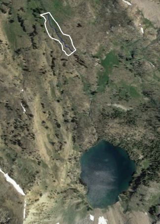
Figure 5: Site 1 location map. This reach is very close to the headwaters, which begin from Gallatin Lake, seen at the lower portion of this image.
|
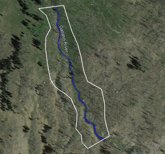
Figure 6: Site 1 with the active channel and valley bottom outlined.
|
Below are the Tier 1 units for Site 1, with the HAND raster provided as backup. The active channel was traced based on the aerial photo from Google Earth (Figure 6 and 7) and the valley bottom was mapped by Google Earth then compared to the HAND raster and VBET valley bottom outline for verification (Figure 8). While the drawn valley bottom and the VBET outline do not exactly match, they follow the same trends. This reach of the Gallatin has a narrow but continuous active floodplain on the downstream end of the reach and active floodplain pockets on the upstream end of the reach. The inactive floodplain is continuous and is characteristic of a glacially-carved valley, as is true of most headwater streams in this area.
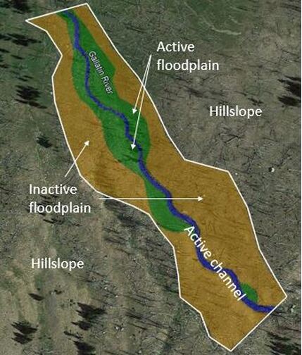
Figure 7: Site 1 with the Tier 1 geomorphic units outlined.
|
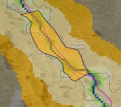
Figure 8: Site 1 valley bottom outline superimposed on the HAND raster from the Riverscapes Consortium.
|
The following equations calculate sinuosity, percent of each Tier 1 geomorphic unit, confinement, average slope, and integrated width. The measurements used for these calculations were taken from the Google Earth Measurement tools.
Sinuosity:
Center line river length / straight line length over the same reach
When sinuosity is... 1.0-1.05 = straight, 1.06-1.30 = low sinuosity, 1.31-1.80 = sinuous, >1.80 = tortuous
Site 1: river length = 0.39 km
Straight line length = 0.36km
Sinuosity = 0.39km / 0.36km = 1.083, low sinuosity
Sinuosity:
Center line river length / straight line length over the same reach
When sinuosity is... 1.0-1.05 = straight, 1.06-1.30 = low sinuosity, 1.31-1.80 = sinuous, >1.80 = tortuous
Site 1: river length = 0.39 km
Straight line length = 0.36km
Sinuosity = 0.39km / 0.36km = 1.083, low sinuosity
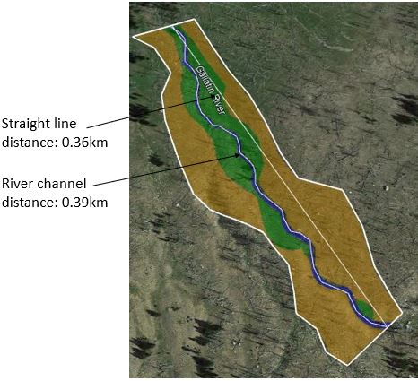
Figure 9: Site 1 with measurements of total stream length and straight line stream length highlighted.
Percent Tier 1 Geomorphic Units (Based on Figure 7)
Area in km2 of Tier 1 unit / total area in km2 of the valley bottom * 100%
Total area of valley bottom: 0.025 km2
Area of active channel: 0.001414 km2
Percent active channel: 5.7%
Area of active floodplain: 0.005884 km2
Percent active floodplain: 23.5%
Area of inactive floodplain: 0.018187 km2
Percent inactive floodplain: 72.7%
This sums to slightly more than 100% but there are errors in the Google Earth measuring tools and these percentages show representative relationships between the Tier 1 units.
Confinement
Length of stream that abuts the valley bottom margin on at least one bank / total stream length * 100%
(Constriction = length of stream that abuts valley bottom margin on both banks)
Length of stream abutting valley bottom margin: 0.0 km
Confinement: 0.0%
Constriction: 0.0%
Average Slope
Elevation of upstream end of reach - Elevation of downstream end of reach / straight line length of the reach
Elevation of upstream end of reach: 2612m
Elevation of downstream end of reach: 2577m
Straight line length of the reach: 360m
Average slope of site 1: 2612 - 2577 / 360 = 0.0972 m/m
Integrated Width
Area of the shape / length of the shape
Area of active channel: .001414km2
Length of active channel: 0.39km
Integrated width of the active channel: 0.001414 / 0.39 = .0036 km (3.6m)
Area of valley bottom: 0.025km2
Length of valley bottom: 0.36km
Integrated width of the valley bottom: 0.025 / 0.36 = 0.069 km (69m)
Instream Geophmorphic Units: This reach is dominated by cascades and rapids, with an average slope of 9.7%.
River Style: Steep, laterally unconfined headwater stream
Site 2: Meandering section in Yellowstone National Park
Site 2 is downstream of site 1 in a wider valley setting with minimal influence from the margins. The active floodplain is well defined via vegetation and the river actively meanders in this area. this reach has a high sinuosity (see Figure 14 and calculations below). The Tier 1 units were estimated based on the detrended DEM (HAND) and the VBET valley bottom outline (See Figures 12 and 13).
Site 2 is downstream of site 1 in a wider valley setting with minimal influence from the margins. The active floodplain is well defined via vegetation and the river actively meanders in this area. this reach has a high sinuosity (see Figure 14 and calculations below). The Tier 1 units were estimated based on the detrended DEM (HAND) and the VBET valley bottom outline (See Figures 12 and 13).
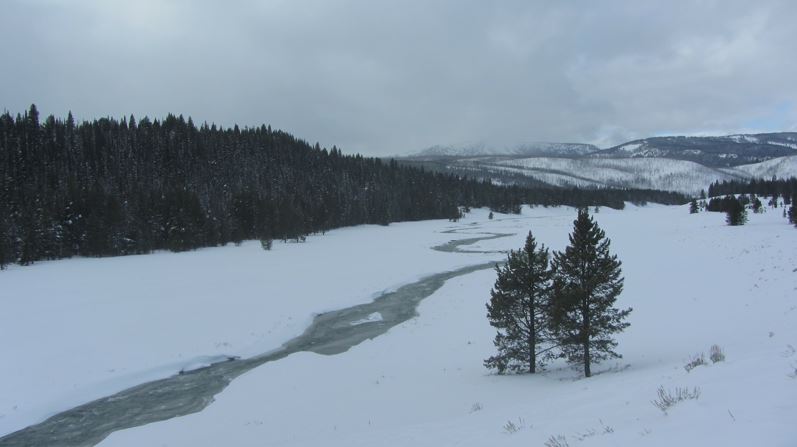
Figure 10: Photo of site 2 in winter showing a wide, flat valley with a meandering channel.
|
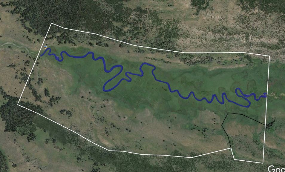
Figure 11: Site 2 map with active channel and valley bottom outlined
|
Below are the Tier 1 units for Site 2, with the HAND raster provided as backup. The active channel was traced based on the aerial photo from Google Earth (Figure 11) and the valley bottom was mapped by Google Earth then compared to the HAND raster and VBET valley bottom outline for verification (Figure 13). The drawn and raster output are very similar, with the drawn valley bottom including a fan on river left , which was not included in the VBET outline. This reach of the Gallatin has gained significant drainage area and drastically reduced slope, so a meandering type river is dominant. The active floodplain is wide and seems often inundated based on vegetation. The fan is probably a remnant from a previous headwater stream that provided flow to the main stem of the Gallatin River.
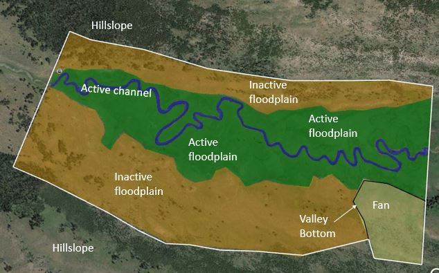
Figure 12: Site 2 with the Tier 1 geomorphic units outlined.
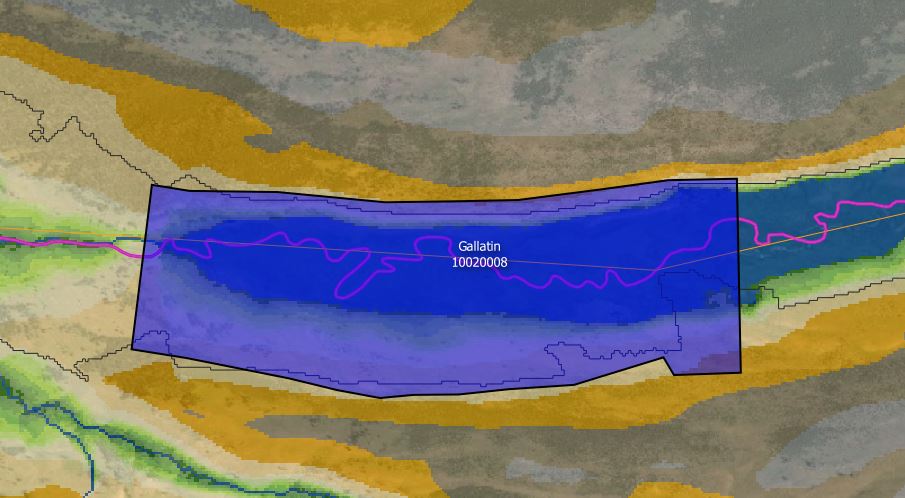
Figure 13: Site 2 valley bottom outline superimposed on the HAND raster from the Riverscapes Consortium.
Calculations (see site 1 for explanation of equations)
Sinuosity:
3.10km / 1.54km = 2.01 (tortuous)
Sinuosity:
3.10km / 1.54km = 2.01 (tortuous)
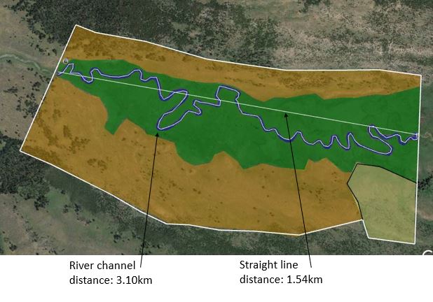
Figure 14: Site 2 with measurements of total stream length and straight line stream length highlighted.
Percent area of tier 1 units:
Valley margin area: 1.078 km2
Active channel: 0.034 km2 (3.2%)
Active floodplain: 0.390 km2 (36.2%)
Inactive floodplain: 0.572 km2 (53.1%)
Fan: 0.062 km2 (5.7%)
Confinement: 0.0%
Average slope: 0.0006 m/m
Integrated width:
Active channel: 0.0112 km (11.2m)
Valley bottom: 0.698 km (698m)
Instream Geomorphic Units: This reach has some lateral and longitudinal bars but is mostly dominated by planar features like runs. The figure below provides an example of the upstream section of the reach.
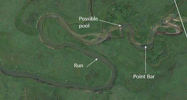
Figure 15: Zoom in of site 2 showing some instream geomorphic units.
River Style: Alpine valley, low slope, unconfined, meandering reach.
Site 3: Along Hwy 191, North of the turn off to Big Sky, MT.
This reach starts at the turn off to Big Sky, MT and runs downstream for approximately 1.25km. This is the downstream end of a alpine valley before the river enters a narrow canyon. The active channel was created by tracing the imagery on Google Earth Pro and was taken as the current wetted area within the reach. This portion of channel was likely straightened when the highway was built, but there are still large areas of active floodplain (Figure 18).
This reach starts at the turn off to Big Sky, MT and runs downstream for approximately 1.25km. This is the downstream end of a alpine valley before the river enters a narrow canyon. The active channel was created by tracing the imagery on Google Earth Pro and was taken as the current wetted area within the reach. This portion of channel was likely straightened when the highway was built, but there are still large areas of active floodplain (Figure 18).
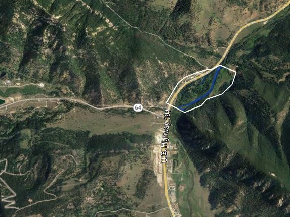
Figure 16: Site 3 location map. This reach is at the turn off to Big Sky, MT and the West Fork of the Gallatin River discharges into the main stem just upstream of this reach. Flow is left to right.
|
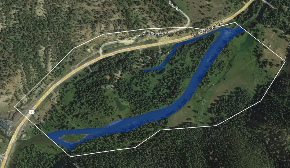
Figure 17: Site 3 map with active channel and valley bottom outlined
|
Below are the Tier 1 units for Site 3, with the HAND raster provided as backup. The valley bottom was mapped by Google Earth then compared to the HAND raster and VBET valley bottom outline for verification (Figure 19). This reach of the Gallatin has gained a significant tributary just upstream from this reach and is entering a confining canyon just downstream from this reach. There are a few houses and a highway along river left that have influenced the location and stability of the river channel in this location. While there is a decent amount of active floodplain, it has probably been reduced in size by the human development in the area. There also appears to be some type of spring entering the Gallatin on river left at the downstream end of the reach.
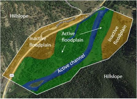
Figure 18: Site 3 with the Tier 1 geomorphic units outlined.
|
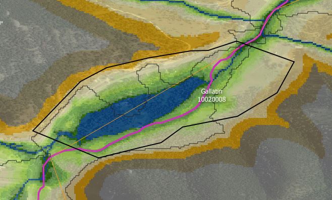
Figure 19: Site 3 valley bottom outline superimposed on the HAND raster from the Riverscapes Consortium.
|
Calculations (see site 1 for explanation of equations)
Sinuosity:
1.00km / 0.96km = 1.04 (straight)
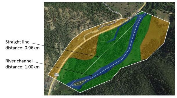
Figure 20: Site 3 with measurements of total stream length and straight line stream length highlighted.
Percent area of tier 1 units:
Valley margin area: 0.438 km2
Active channel: 0.052 km2 (11.8%)
Active floodplain: 0.213 km2 (48.6%)
Inactive floodplain: 0.165 km2 (37.7%)
Confinement: 0.0%
Average slope: 0.0052 m/m
Integrated width:
Active channel: 0.051 km (51.3m)
Valley bottom: 0.458 km (458m)
Instream Geomorphic Units: This reach has some lateral bars but is mostly dominated by planar features like runs, with a few riffle crests at slope changes. This is lack of diverse river features is probably due to the anthropogenic influence of the homes and highway that are close to the river. The figure below provides an example of the upstream section of the reach.
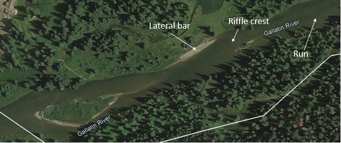
Figure 21: Zoom in of site 3 showing some instream geomorphic units.
River Style: Fairly straight, unconfined but anthropologically straightened and controlled transfer reach.
Site 4: In Gallatin Canyon, near Lava Lake Trailhead
This site parallels the highway and mostly consists of large boulders, and while the reach is not very steep, these large roughness elements still create a turbulent environment (see Figure 23). This is in a confined valley with a small floodplain on one side that is mostly occupied by the highway. This was a short reach with minimal sinuosity. The Tier 1 units were estimated based on the detrended DEM (HAND) and the VBET valley bottom outline (See Figures 24 and 25).
This site parallels the highway and mostly consists of large boulders, and while the reach is not very steep, these large roughness elements still create a turbulent environment (see Figure 23). This is in a confined valley with a small floodplain on one side that is mostly occupied by the highway. This was a short reach with minimal sinuosity. The Tier 1 units were estimated based on the detrended DEM (HAND) and the VBET valley bottom outline (See Figures 24 and 25).
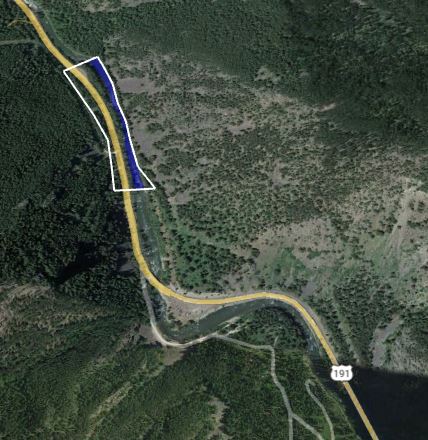
Figure 22: Site 4 map with active channel and valley bottom outlined
|
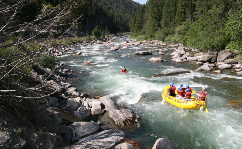
Figure 23: Photo of site 4 showing the geomorphic units and river slope
|
Below are the Tier 1 units for Site 4, with the HAND raster provided as backup. The valley bottom was mapped by Google Earth then compared to the HAND raster and VBET valley bottom outline for verification (Figure 25). This reach of the Gallatin is in a confined valley and is a confined reach, with the upstream end of the reach having a small floodplain pocket on each bank. The highway parallels this stretch of river and prevents channel change, although the valley in narrow enough that the channel would have minimal room for movement even without the highway. This reach is mostly a series of rapids.
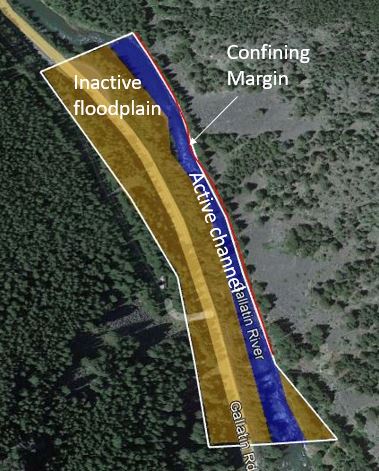
Figure 24: Site 4 with the Tier 1 geomorphic units outlined.
|
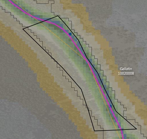
Figure 25: Site 4 valley bottom outline superimposed on the HAND raster from the Riverscapes Consortium.
|
Calculations (see site 1 for explanation of equations)
Sinuosity:
0.43km / 0.43km = 1.0 (straight)
Sinuosity:
0.43km / 0.43km = 1.0 (straight)
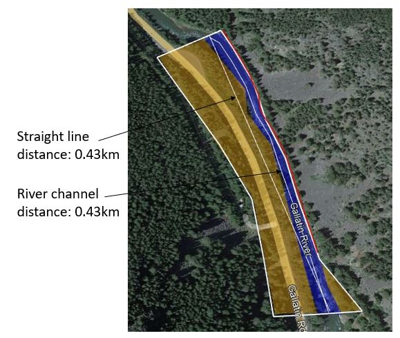
Figure 26: Site 4 with measurements of total stream length and straight line stream length highlighted.
Percent area of tier 1 units:
Valley margin area: 0.033 km2
Active channel: 0.0076 km2 (23.3%)
Active floodplain: 0.0 km2 (0.0%)
Inactive floodplain: 0.024 km2 (74.7%)
Confinement: 90.7%
Average slope: 0.0088 m/m
Integrated width:
Active channel: 0.0176 km (17.6m)
Valley bottom: 0.0767 km (76.7m)
Instream Geomorphic Units: This reach is dominated by structurally forced rapids and pools due to the large amount of boulders in the area. The slope is low so forcing must be present to create these rapid-type features.
River Style: Straight, confined, high energy, low slope reach
Site 5: In Gallatin Valley, near Bozeman, MT
Site 5 is in the Gallatin Valley on a wide floodplain just outside the town of Gallatin Gateway, MT. There are many roads that parallel and cross the river in this area, but the river still has a large, mostly undisturbed active floodplain. The surrounding agricultural land make up most of the inactive floodplain and there are multiple remnant, low angle fans that border the valley bottom. The Tier 1 units were estimated based on the detrended DEM (HAND) and the VBET valley bottom outline (See Figures 29 through 31).
Site 5 is in the Gallatin Valley on a wide floodplain just outside the town of Gallatin Gateway, MT. There are many roads that parallel and cross the river in this area, but the river still has a large, mostly undisturbed active floodplain. The surrounding agricultural land make up most of the inactive floodplain and there are multiple remnant, low angle fans that border the valley bottom. The Tier 1 units were estimated based on the detrended DEM (HAND) and the VBET valley bottom outline (See Figures 29 through 31).
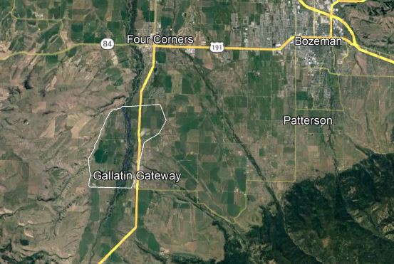
Figure 27: Site 5 location map. This reach is in the Gallatin Valley, just outside the city of Bozeman, MT. Flow is from the bottom of the image to the top.
|
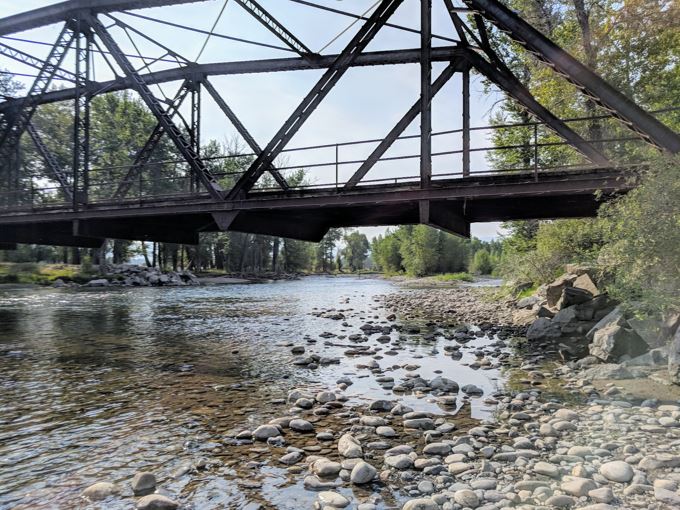
Figure 28: Photo of site 5 showing the wide, shallow river with gravel bars.
|
Below are the Tier 1 units for Site 5, with the HAND raster provided as backup. The valley bottom was mapped by Google Earth then compared to the HAND raster and VBET valley bottom outline for verification (Figure 29 and 30). This reach of the Gallatin runs through a wide valley bottom that is probably filled with glacial outwash. The channel has an active floodplain, including many islands, that are often inundated during the spring runoff season. There is some amount of sinuosity but this reach is mostly unique for its multi channel characteristics.
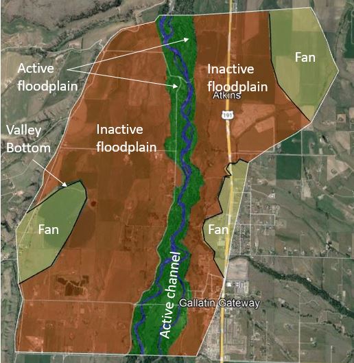
Figure 29: Site 5 with the Tier 1 geomorphic units outlined.
|
Figure 30: Site 5 valley bottom outline superimposed on the VBET raster from the Riverscapes Consortium.
Figure 31: Site 5 valley bottom outline superimposed on the HAND raster from the Riverscapes Consortium.
|
Calculations (see site 1 for explanation of equations)
Sinuosity:
6.23km / 5.38km = 1.16 (low sinuosity)
Sinuosity:
6.23km / 5.38km = 1.16 (low sinuosity)
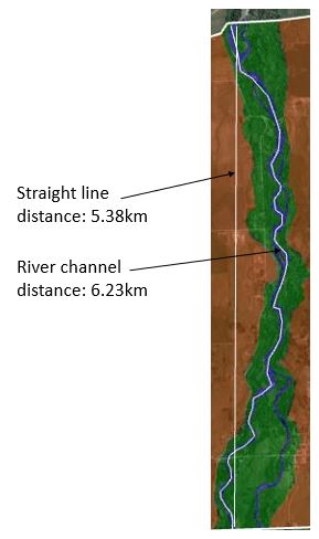
Figure 32: Site 5 with measurements of total stream length and straight line stream length highlighted.
Percent area of tier 1 units:
Valley margin area: 18.6 km2
Active channel: 0.416 km2 (2.2%)
Active floodplain: 2.206 km2 (11.7%)
Inactive floodplain: 12.707 km2 (68.3%)
Fan: 3.031 km2 (16.3%)
Confinement: 0.0%
Average slope: 0.0078 m/m
Integrated width:
Active channel: 0.067 km (67m)
Valley bottom: 3.457 km (3457m)
Instream Geomorphic Units: This reach is very diverse in its geomorphic units. There are many types of bars, as well as many pool and riffle sequences. This portion of the river is fairly dynamic compared to the upstream reaches so the bars get reset from time to time. See the figure below for an example of some of the bars present.
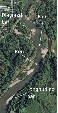
Figure 33: Zoom in of site 5 showing some instream geomorphic units.
River Style: Low slope, low sinuosity, multichannel reach
Synthesis
Overall, the reaches that were selected each had unique characteristics when compared to each other. Site 1, at the headwaters, was extremely steep and boulder dominated, while sites 2 and 5 were in valleys with minimal slope and more room to move. Sites 3 and 4 were highly modified by humans through the installation of the highway that runs through Gallatin Canyon. Site 5 was also modified in terms of the size of its floodplain. Sites 1 and 2 were within Yellowstone National Park and are therefore, more protected from human impacts. There were some trends seen in this watershed as one moved down stream (smaller grain sizes down stream and higher slopes upstream), but the impacts of humans have significantly altered a large portion of this watershed, affecting how the river moves sediment through the system, as well as how the river moves within and accesses its floodplain.
